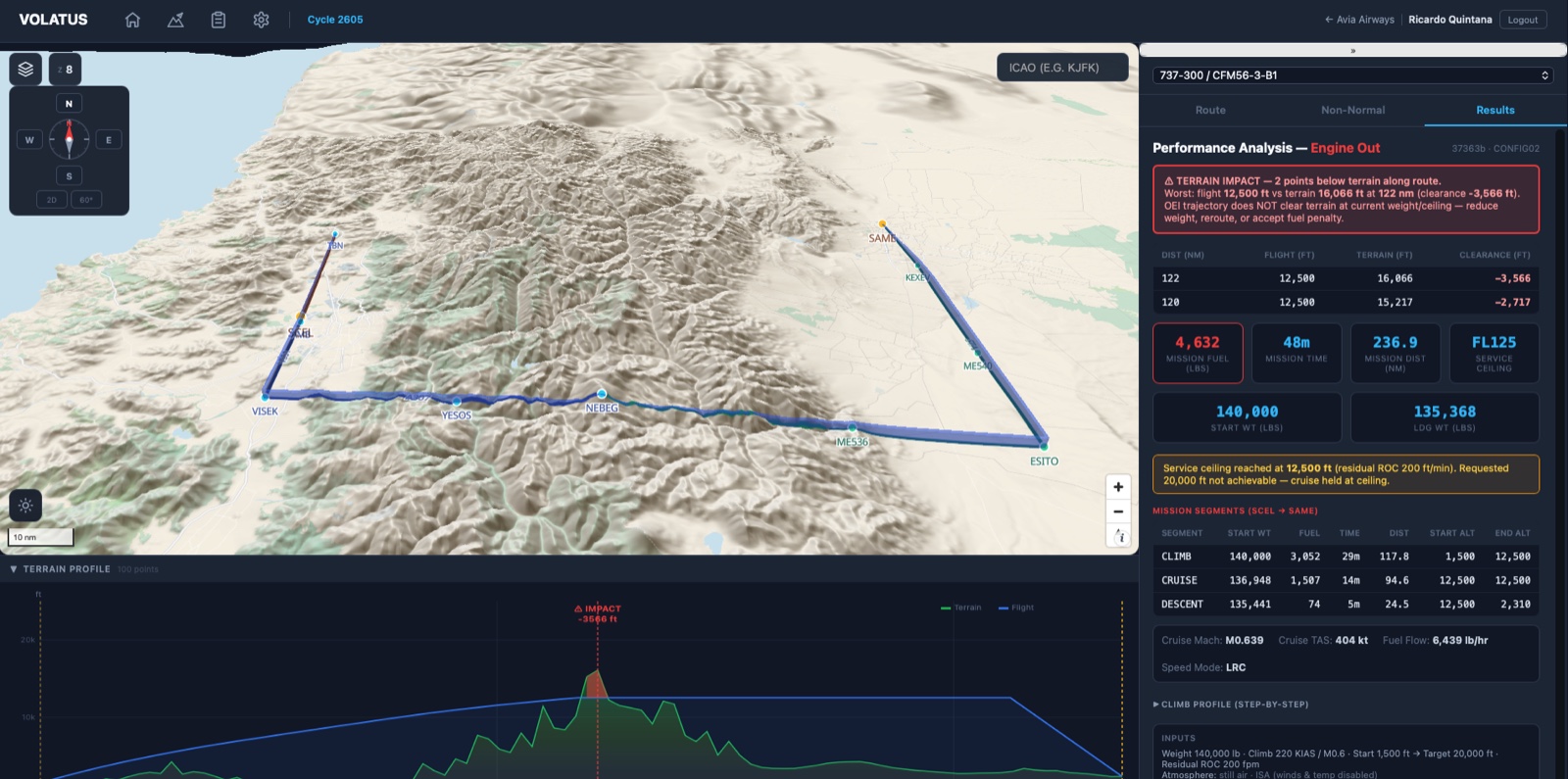
Volatus 3D terrain map with the engine-out route and the performance analysis panel

Flight Planning & Dispatch

Volatus

Most planning software formats a route you already chose. Volatus finds the route, flies it on the manufacturer’s certified performance data, and then answers the harder question — what that same flight does with one engine out.

A* airway routingSID / STARTerrain profileWinds aloft Engine out & driftdownCost by flight levelTankeringJeppesen OFP

Why it is different

Three things, and they are the whole product.

01

The engine is the manufacturer’s

Climb, cruise, descent, driftdown and altitude capability across 13 Boeing types — roughly 27,000 lines of certified Fortran ported to Rust. Your fuel and time are computed, not estimated.

02

The flight you did not plan for

Engine failure on climb, driftdown from any point in cruise, a gear that will not retract — computed on the same route, the same weight and the same wind as the release sitting next to it.

03

What it costs, level by level

Every candidate cruise level priced: time, fuel, wind component and trip cost — fuel at the departure field, overflight and airport charges, in one currency.

Routing

It builds the route. Not just the paperwork.

An A* traversal of the live airway network of the current AIRAC cycle, with the terminal procedures, the alternate and the terrain solved as part of the same problem.
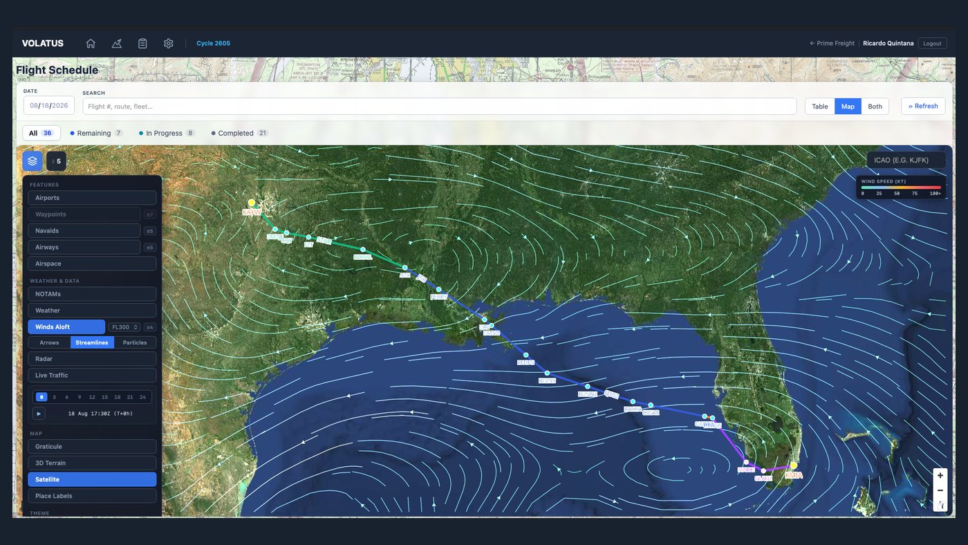
Volatus route across the Gulf of Mexico with winds aloft rendered as streamlines over a satellite basemap

Airways, procedures, alternates

The chart is the tool.

  • A* over the airway graph of the current cycle, with level filters applied and magnetic variation from the WMM 2024–2029 model per waypoint.
  • Alternates routed through airways too — not drawn as a great-circle line, and with their own distance.
  • Every layer live: navigation, weather, NOTAMs, radar and traffic, over aeronautical, satellite or 3D terrain.
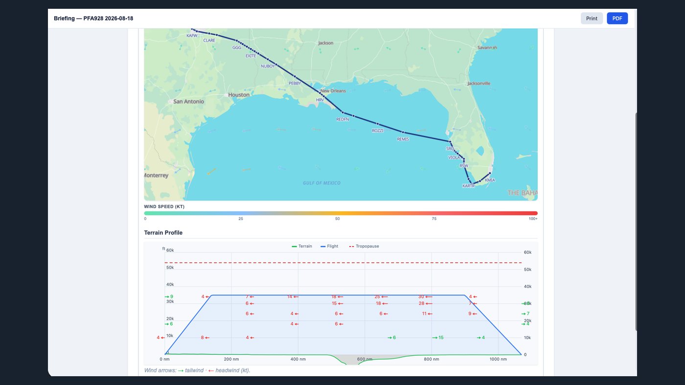
Volatus terrain profile with the flight path, tropopause and head and tailwind components along the route

Terrain

Clearance you look at, not infer.

The whole route against real SRTM elevation at roughly 30 metres, main leg and alternate on one continuous scale — from an elevation service that runs on your side of the wire.

Winds aloft

Three ways to read the same wind.

Arrows, streamlines and moving particles, at the flight level you select, coloured by speed. Step the field forward in three-hour increments out to twenty-four, and watch what the route flies into.

Arrows Direction and speed read off the chart, in knots, at every grid point.
Streamlines Continuous flow lines — where the air is going, and where it turns.
Particles The field in motion — speed and direction read as flow, not as numbers.

Non-normal

The question nobody wants to answer at the time.

Lose an engine over high terrain, or a gear that will not retract, and the answer has to already exist. Volatus computes it on the route you are actually flying — in still air and ISA for the book number, or on the day’s wind and temperature when you want the real one.
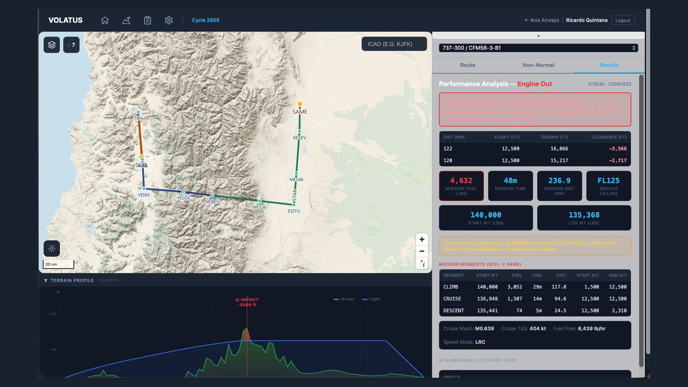
Volatus engine-out performance analysis showing negative terrain clearance, mission figures and segment breakdown

Three cases, one route

Enroute climb, driftdown, gear down.

  • Engine out on climb — climb power on the remaining engine, no 250/10,000 restriction. If the level you asked for is not achievable, it says what is, and at what residual rate of climb.
  • Driftdown from any point you choose, at the weight and speed the aircraft actually has there: net path with the FAR 25.123 penalty, 2,000 ft of margin descending, 1,000 ft at the ceiling.
  • Gear down to the destination — climb, cruise and descent in that configuration, below Vle. The answer is fuel, time and distance, not a rate of climb.
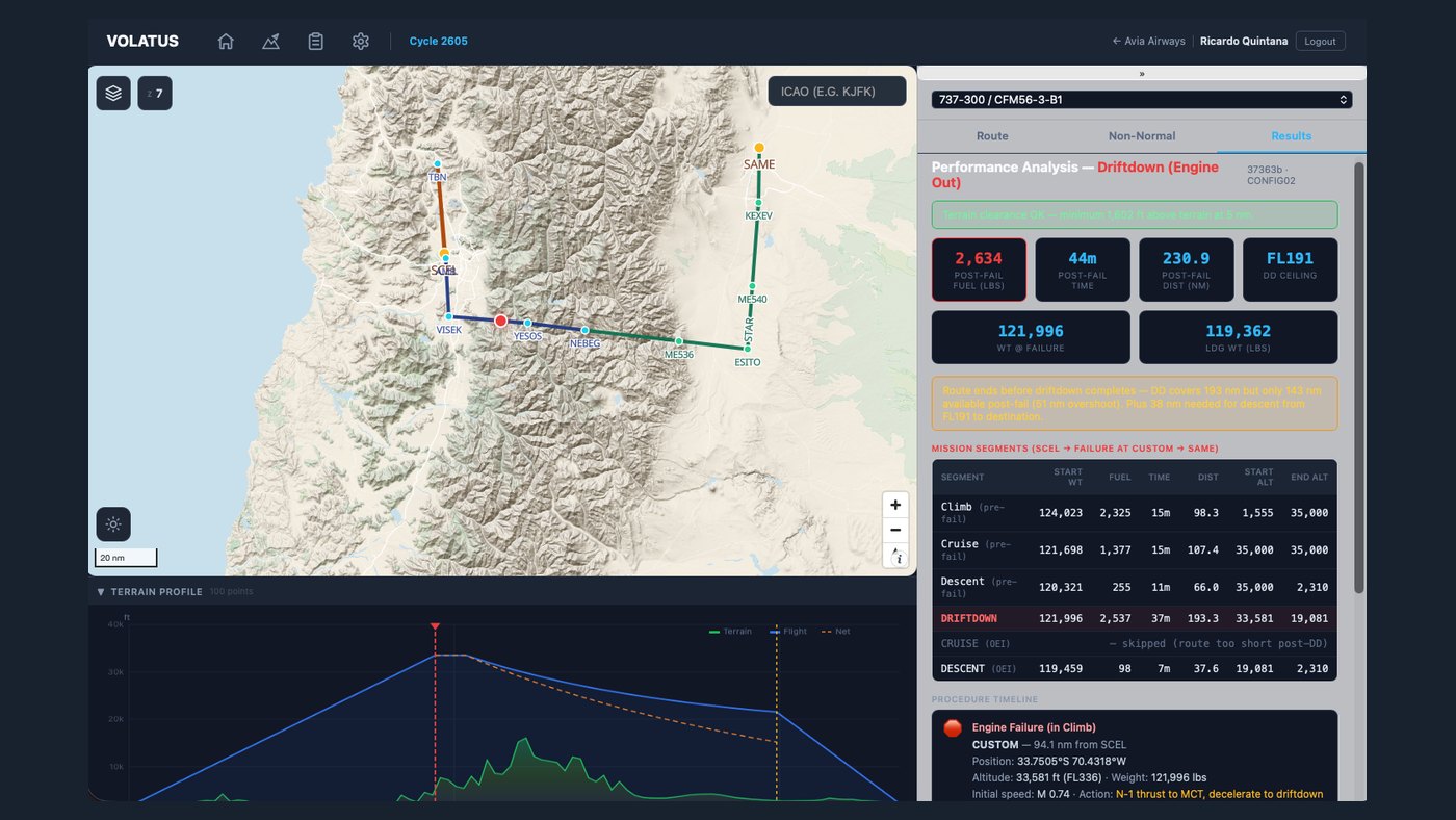
Volatus driftdown analysis with the failure point on the route, post-failure figures and the procedure timeline

The same engine, the same aircraft, the same day. Clearance is checked point by point, and where it goes negative it says so in red. If the driftdown needs more track than the route has left, it says how much is missing. None of it is a separate tool with its own assumptions — which is the only way it can be compared with the release next to it.

The money

Not the cheapest level. The cheapest flight.

The same engine that produces the release flies the trip again across a band of cruise levels. Each one comes back priced.
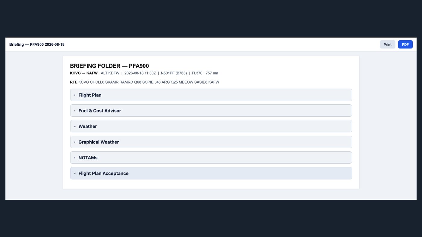
Volatus briefing folder for a flight, with flight plan, fuel and cost advisor, weather, NOTAMs and acceptance sections

Fuel & cost advisor

Every level, with its bill attached.

  • Altitude and cost grid — time, fuel, wind component and total trip cost per flight level: fuel at the departure field, overflight and airport charges, in one currency.
  • Gated on the operational ceiling, not the bare one: the lower of the thrust limit at that level’s top-of-climb weight and the buffet limit with a manoeuvre margin. A level the book will not give you never appears as an option.
  • Tankering — uplift at the cheap station or buy at the next one, with the carry-burn penalty measured by running the engine both ways, bounded by MTOW, tank capacity and landing weight.
  • The costs that are not fuel — landing, passenger and overflight charges, crew hotel, ground transport and per diem.

The briefing

One folder, and the crew is briefed.

Flight plan, fuel and cost, weather, graphical weather, NOTAMs and the flight plan acceptance — assembled for the flight, on screen, and out as a PDF for the folder.
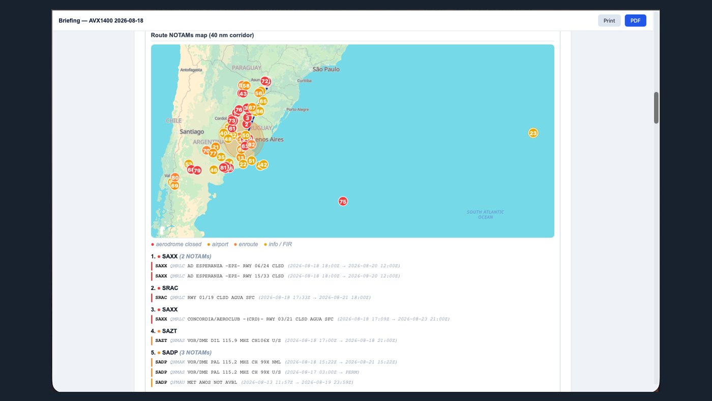
Volatus route NOTAMs map showing clustered NOTAMs in a 40 nautical mile corridor with decoded text below

NOTAMs

The ones on your route. Not the ones in the country.

  • A corridor, not a country — a forty-nautical-mile band either side of the route actually filed, clustered on the chart so a busy terminal area reads as one marker with a count.
  • Decoded, with the raw text kept — Q-code resolved, validity window shown, classified and colour-coded, the original underneath for whoever wants it.
  • METAR, TAF and GFS winds aloft alongside them, printed or exported with the rest of the folder.

Volatus — iPad · for pilots · early access

The same plan, on the flight deck.

Where it stands. A native iPad application — a real moving map, not a web page in a wrapper — on the same navigation database and the same performance engine as the dispatcher’s screen. In active development, available to launch customers as an early-access build. We would rather say that than imply parity it does not yet have — ask us what is in the current build.

At a glance

Specifications

Plan one of your real flights with us.

Give us a city pair, an aircraft and a day. We will build the release — route, terrain, winds, fuel and OFP — and walk you through it.